15

I am making my own LotR-themed Risk game and I am having trouble finding a very accurate map of Arda before Beleriand was lost. This map should include Valinor and Númenor as well.

The best I can find so far appears to be a map from David Day's "Tolkien Bestiary"

Map of Arda

6
  • 13
    Well, Numenor didn't exist until after Beleriand was destroyed; you will have to make a choice there. Commented May 13, 2015 at 15:47
  • 4
    You may want to look into The Atlas of Middle-earth. It's not perfect, but it's quite comprehensive Commented May 13, 2015 at 15:47
  • 3
    Yes, The Atlas of Middle-Earth is the best there is out there. That map you mentionned is really not accurate. As an exemple, Numenor is supposed to be star shaped, and The Shire would be west of Beleriand, not south... try this one instead: elvenesse.net/maps/Arda_FirstAge.gif.
    – Joel
    Commented May 13, 2015 at 15:58
  • 8
    The map you included in your question is widely regarded as the worst map of Arda ever made.
    – Wad Cheber
    Commented Jul 19, 2015 at 3:49
  • 2
    @Wad Cheber I did not suspect that, as I really enjoyed the rest of the bestiary and art in the book. As for Numenor not existing at the time, that's alright. I just wanted an approximate location of every continent that had existed.
    – user45549
    Commented Jul 20, 2015 at 19:59

2 Answers 2

20

David Day's map is widely regarded as one of the worst examples of Arda. His work is often criticised in the Tolkien community. Your best bet is to stitch together a number of maps.

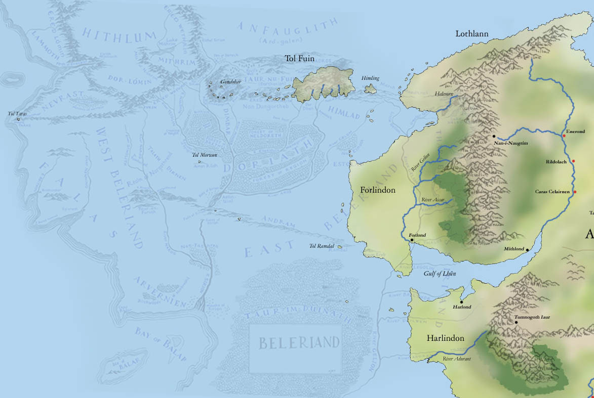
One map superimposes a sunken Beleriand on to Western Middle-earth seen here A map superimposing the sunken Beleriand onto Western Middle-earth
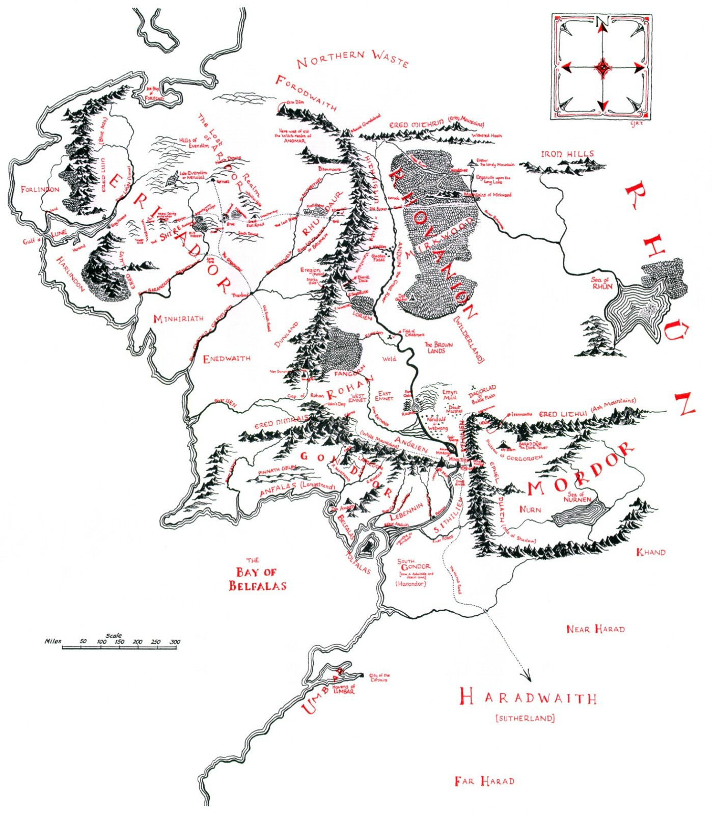
The rest of Middle-earth can be seen here: Map of Middle-earth in the Third Age as it was seen in the Lord of the Rings
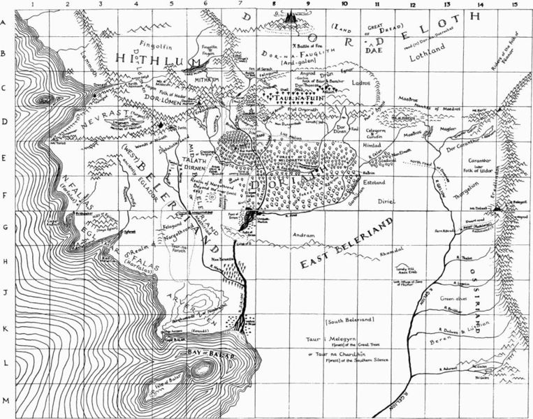
A map of Beleriand which was drawn by Tolkien: Map of Middle-earth before the destruction of Beleriand and the end of the First Age
As far as I remember there are no good maps of Arda that include Aman. I can't of the top of my head even remember if there was a map of Aman drawn. Outside of Tolkien's own drawings The Atlas of Middle-earth is probably your best shot.

As @Joel pointed out resources on Aman can be found in The Atlas of Middle-earth, it's not canon but apparently very good.

5
  • Yes, there are a couple of maps including Aman, in the "Atlas of Middle-earth" by Karen Wynn Fonstadt
    – Joel
    Commented May 13, 2015 at 16:02
  • I'm generally reluctant to include any non-tolkien resources but I've been recommended the Atlas of Middle-earth a number of times now, might take a look at it.
    – Conor O'D
    Commented May 13, 2015 at 16:05
  • 2
    Fonstadt is a professionnal cartographer and she made a really good job, I've been having my copy of it for more than 20 years and it is very accurate, very much alike those of Tolkien and his son (which are not perfect by their own aknoledgement anyway), even though there are small errors (but more in the texts than in the maps), which are listed in the link Jason provided in his comment: tolkiengateway.net/wiki/Atlas_of_Middle-earth
    – Joel
    Commented May 13, 2015 at 16:14
  • In this superposition beleriand is too small (wrong scale)
    – Mithoron
    Commented May 13, 2015 at 17:44
  • 1
    There is now also an interactive Map about all the different ages. arda-maps.org/ages/second Is this what you are looking for?
    – kwoxer
    Commented Aug 13, 2015 at 8:57
13

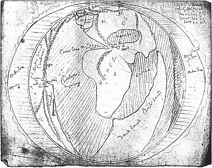
You can't get more accurate than a map drawn by Tolkien himself. Here is one such map:

Tolkien's sketch of all of Middle-earth within the Outer Sea

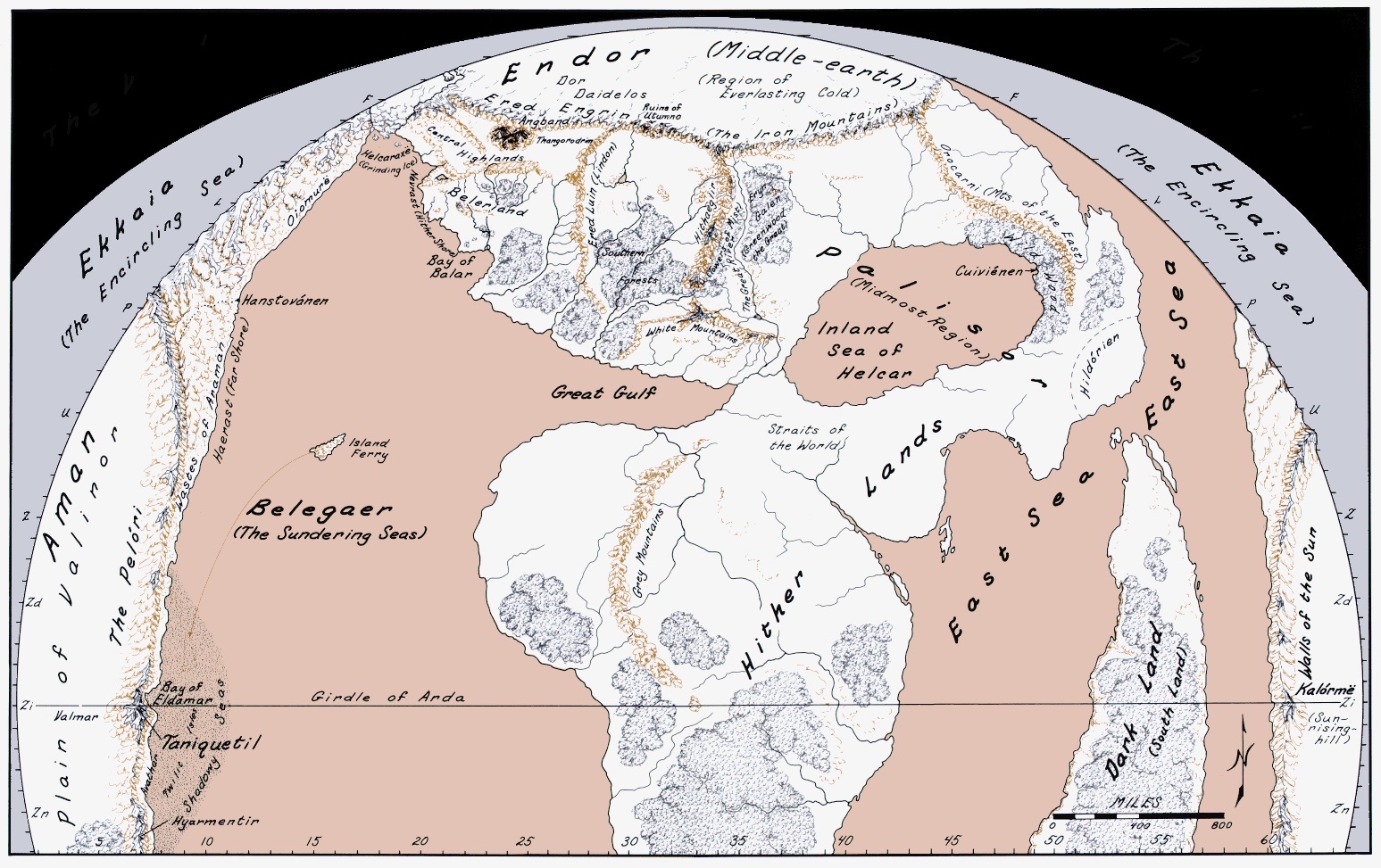
And a much larger, more legible version of the same map, drawn from Tolkien's original, by Karen Wynn Fontstadt:

Map of Middle-earth by Fontstadt per Tolkien's original; more detail, colour

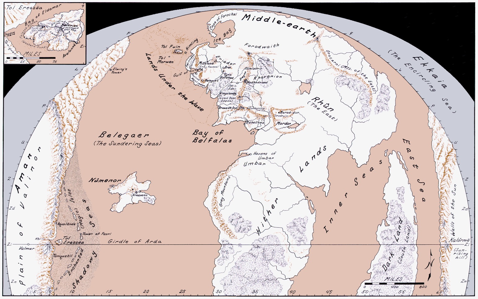
Because Númenor and Beleriand didn't exist at the same time, it is impossible to find an accurate map showing both. Here is Karen Wynn Fontstadt's map of Arda in the Second Age, including Númenor (but not Beleriand):

The same view of Middle-earth as the previous map, but updated for the Second Age (Númenor is raised, Beleriand is sunken).

Note: Click the links to see the full size maps

1
  • 4
    But there are much more Tolkien drawed images. But exactly the first one here is showing most of the important details Tolkien wanted to set a focus on. About the other pictures, there is a project I just released into Beta: arda-maps.org it is using 200 different maps and merging them into the three maps you can now freely explore. Hope you like it. =)
    – kwoxer
    Commented Aug 13, 2015 at 9:08

Your Answer

By clicking “Post Your Answer”, you agree to our terms of service and acknowledge you have read our privacy policy.